Navigating Scotland
by Volker Weber
When we arrived at Edinburgh airport, we picked up a car from Hertz. Now it was time to solve three problems. All at the same time:
1. How to drive while sitting on the right side of the car.
2. Driving on the left side of the road.
3. Finding our way to the Glenallan.
I had to pick up task #1, Ute #3 and together we mastered #2. At this point it was really helpful to have a navigator.
I used the same GPS receiver as in this test. Shortly before we departed I received a map for the UK, which fits on a 128 meg card (Germany needs 256 meg). It came with the software for the PocketPC and I was quite surprised that the Tungsten would see the chip but would not play with the map. I am assuming incompatibilities between the PPC (3.0) and the Tungsten (4.1) version. They looked pretty much the same, but would not work in the other device.
So we used Ute's Xda II to host the software. Unfortunately we did not have a charger cable nor a dashboard mount so it was a bit tricky to use. The software burns through a full charge of the Xda in less than two hours, and on one occasion we forgot to switch off the GPS receiver in the evening, so it was dead the next day.
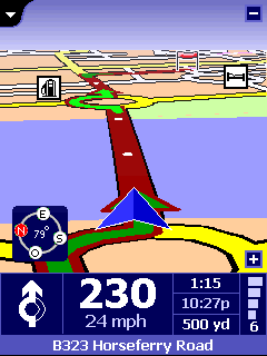
Moving around the city turned out to be equally good as it is with the German map. Routing was considerably slower than on the Tungsten, but that may be due to the cheaper SD chip we used. Although the map contained even the smallest farm roads, we ran into one issue: Many streets in the remote areas of Scotland do not have a name. So you cannot just enter a proper street address. And I never figured out how to enter post codes that were not readily displayed in the selection box. Nick gave us a good explanation over the phone of his whereabouts and I was able to spot the tiny farm road to the Old Mill on the navigator map. For Mark Smith's home, I copied from a map he sent me before we arrived.
When we didn't have to go through a major city or spot a remote location, we never used the navigator though. There are not that many roads in the remote landscapes of Scotland and they can easily be navigated by the road signs. The only time I missed the navigator when I did not take it to the Kinnaird Estate and our tired hosts had to show us the way home.
One technical tidbit: Other than the T3, the Xda never had difficulties connecting to the GPS receiver over Bluetooth.
Comments
i use tomtom myself, and i used to be (or still am?) the keeper of the tomtom faq at pocketnavigation.de but i am surprised that tomtom on a windows mobile device runs slower than on a tungsten.
i always thought that xscale 400mhz cpus are faster than whatever some palm based thing has (actually i never owned a palm based system, so i just had that assumption my whole life).
it could be ofcourse because of the sd card. we noticed huge differences between the various brands (while sandisk always took the last rank).
PS: when i was on new years eve vacation last winter in london it was hard enough to get used to the "wrong way driving" thing as a pedestrian. i would have never tried to drive a car there :)
Both the XDA2 and the T3 have a 400 MHz Xscale CPU. And the T3 has less software overhead.
Unrelated to performance, one should add that the T3 display is 320x480 while the XDA2 has 240x320.