Geocoding your photos with Nokia Sports Tracker
by Volker Weber
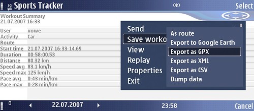
When I first wrote about the Nokia Sports Tracker, I was a bit disappointed that it would not export tracks in a format that contained date/time information for the recorded waypoints. Without them you can't use the tracks to geocoding your photos. As I was discussing an upcoming application for the BlackBerry 88xx, I tried to find out about GPX support. This is where I noticed that there is a new version 1.49 of Sports Tracker which was released mid-June (I wonder how I managed to download the old version). 1.49 adds GPX and CSV export:
Sports Tracker runs on S60 3.0 and S60 3.1 devices. There are two different downloads:
- Nokia N71, N73, N75, N76, N80, N80ie, N91, N92, N93, N93i, E50, E60, E61, E62, E65, E70, 3250, 5500 Sport, 6290; S60 3.0 (04-06-2007)
- Nokia N95, E61i, E90, 6110 Navigator; S60 3.1 (04-06-2007)
The N95, E90 and 6110 Navigator have GPS, the others will need a Bluetooth GPS receiver. Now that Sports Tracker lets you export a GPX track, you have all you need to geocode all your photos that were taken during the time the track was recorded. Last year I wrote how you do that.
Of course I had to try it out and stepped out to snap a few pictures while Sports Tracker was running. The internal camera of the E90 does not try to geocode its photos, but since the camera and the track are perfectly time-synced, the choice of camera was simple. :-)
Comments
Since I'm not using a Nokia mobile but a Nikon D70, the Sony GPS-CS1 is just perfect for me. Of course time synchronisation is a little bit more tricky, when using two devices and the Sony software is quite "rudimentary" ;)
To convert it to other formats (such as Google Earth's kmz and many other) I'm using http://www.gpsvisualizer.com.
Does the Nokia Sports Tracker fill in the name of the city, country and province into the IPTC header automatically? That would actually be a feature I'm missing...
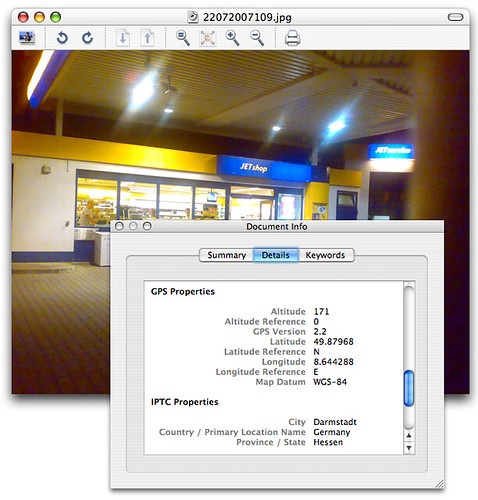
Sports Tracker does not tag the photos. It just provides the track for tagging them. The software that I use to actually tag the photos does fill in the IPTC header as seen in last picture.
Tell us a little more about GPS-CS1. How does it organize tracks? What is the format of the track? Does it connect to the computer like a USB thumbdrive?
Für Tracking-Aufgaben erscheinen mir GPS-Mäuse wie der Wintec WBT-201 interessant. Im Gegensatz zu dem nur wenige Funktionen bietenden und dafür recht teurem Sony-Gerät bieten diese vernünftige Empfänger, Nutzbarkeit auch als GPS-Maus für Handy/PDA sowie Aufzeichnung von Tracks (automatisch oder manuell ausgelöst) und Wegpunkten (auf Knopfdruck). Zudem werden Standard-Handyakkus verwendet, die günstig zu haben sind, so daß man auch auf längeren Touren nicht Gefahr laufen muss, auf dem Trockenen zu sitzen.
Hmm, how About voip-functionality on the E90? Skype, SIP, etc.?! Does it work? THATS the facts I'm waiting for ... But in the Meantime I had better bought an OpenMoko I thought :-(
The OpenMoko? ROFLMAO.
Another important function of Sports Tracker is that you can use it to find GPS satellites. The maps software included with the E90 has big problems to get any GPS reception. If you start Sports Tracker first it works -;))
I sent my E90 back after a couple of days ...
For geotagging photos one might also take a look at ShoZu (http://www.shozu.com) Shozu can tag the photo and - if you want - upload it to flickr (or many other destinations like e-mail,picasa, TypePad and many more). If you want/need to upload it to several destinations the upload via phone is only done once.
Interesting. I did not know that. However, I have now tried ShoZu for the second time and somehow I don't like it.
With Sports Tracker I also want so solve a different problem: Geotagging photos of a "real" camera. :-)
Well, it's quite simple. The Sony GPS-CS1 is a USB device with 32MB of storage and a GPS receiver. So when connecting it to your computer, it shows up as a storage device. It tracks your position every 5 seconds and writes it to a plain ASCII file:
@Sonygps/ver1.0/wgs-84
$GPGGA,083602,5433.2428,N,00928.0311,E,1,05,01.5,00031.3,M,044.9,M,,*49
$GPGSA,A,3,01,11,17,20,23,,,,,,,,03.8,01.5,03.5*0F
$GPGSV,2,1,07,01,45,059,46,11,41,158,52,13,14,206,00,17,39,266,35*76
$GPGSV,2,2,07,20,86,084,50,23,43,194,50,30,02,021,00,,,,*46
It's very important to adjust the time settings within your camera, so there is no offset when merging images and GPS coordinates.
Now you have to copy your images as well as your track file to your computer. There is a very simple software that comes with the device to load the track, select images and geo-tag them. But it only fills in your GPS coordinates into the destined EXIF field - no IPTC.
Using the converters on http://www.gpsvisualizer.com you can convert the track to a kmz file and display it in Google Earth. Unfortunately there is no software to visualize your geo-tagged images on a map in a cute way - at least I haven't found any good software for this purpose.
Those are NMEA 183 sentences. Most software will either work directly with them, or you can convert them to the Garmin GPX format. Does the GPS display the current time on its display. If so, just take a picture of that clock and you know the time difference between the camera and the GPS. The software that tags the images can sometimes adjust with a time offset.
I use gpicsync to tag my D70 RAW files. The tool also writes location names into the header....
You have to synchronise the camera clock with the GPS device BEFORE you start. The device doesn't have a display and you can only choose the time zone of your camera's clock once when importing the track file, e.g. GMT+1. There is some tolerance, but you need to adjust your camera's clock every now and then.
talking about shozu, i cannot find the geotag in my pics when uploaded to picasa. nokia sports tracker works fine, when you last wrote about it vowe, i got the latest version... now i even bought google earth plus ($20) for an easy import of the tracks.
Thanks Michael for the gpicsync-link! Looks very promising, didn't know it yet.
(As far as logging devices are concerned, some models do not write the datapoints in fixed intervals but depending on the speed traveled - saving storage space and improving data quality at the same time.)